


Shop

(Italiano) CARTE DU PAIS SITUE ENTRE BOLOGNE ET FERRARE
€240.00
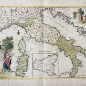
(Italiano) AUTORE: De La Lande
ANNO: 1761
DIMENSIONI: 265x385mm
TECNICA: Incisione in rame
Carta ritraente le province di Bologna e Ferrara disegnata dal cartografo A. Barufaldi dall’atlante francese “Voyage en Italie” di De La Lande.
Esemplare in ottimo stato di conservazione.
Reviews
There are no reviews yet.